|
PT. DSJ Surveying
|
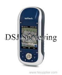
Ashtech ProMark 120 Receiver with L1 GPS/GLONASS
| Price: | 3560.0 USD |
| Payment Terms: | T/T,D/P,WU,Money Gram |
|
|
|
| Add to My Favorites | |
| HiSupplier Escrow |
Product Detail
It comes equipped with ProMark Field software 3.0 from Spectra that provides versatile solutions ideal for processing and analyzing GNSS survey data.
Product Highlights
High-precision measurement
On-board ProMark Field Software
Fast RTK fix
1 cm accuracy
GPS and GLONASS
Windows Embedded 6.5 operating system
Built-in wireless communication support
Extended memory and battery
High-precision measurement with Ashtech Z-Blade Technology
User-friendly and Intuitive ProMark Field Software
Fast RTK fix
Extended productivity on very demanding or obstructed environments
RTK, GLONASS, and GIS Options
Windows Embedded 6.5 operating system for familiar interface
Built-in wireless communication support
Extended memory and battery capacity for all day operation
Lightweight and rugged handheld design
Water resistant with IP65
Alphanumeric touchscreen keyboard
4 - way navigation
Up to 99.9% reliability rate
10 languages available
High resolution sunlight readable display
3M pixels camera
E- Compass and G-sensor
Microphone and speaker
Overview for the Ashtech ProMark 120 Receiver with L1 GPS/GLONASS
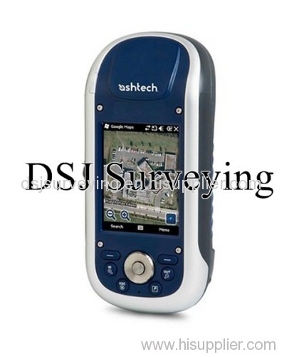
The Ashtech ProMark 120 Receiver from Spectra provides surveyors with an expanded set of GNSS capabilities and enhancements from its previous model (ProMark 100). Used for accurately mapping out survey sites, the handheld receiver comes equipped with a GPS and GLONASS single-frequency antenna for fast land surveying results.
Upgradable Options
This Windows-embedded Ashtech GPS receiver can be easily upgraded to include RTK and NTRIP/DIP options, as well as GLONASS option that enable better RTK performance on your ProMark 120. These options also allow the device to be used in post-processing and GIS applications for complete versatility.
Z-Blade Technology
Surveying in crowded locations and around obstructions can be tough. With the embedded AshTech Z-Blade technology on the ProMark 120, both GPS and GLONASS satellites are fully utilized to obtain a much more reliable GNSS position than standard GPS receivers.
Ashtech ProMark Field Software
The Ashtech ProMark 120 comes equipped with ProMark Field software 3.0 from Spectra that provides versatile solutions ideal for processing and analyzing GNSS survey data. This software features a custom touchscreen keyboard and many other improvements that enhance its user-friendliness.
Windows Mobile 6.5
Utilizing Windows Mobile 6.5, this latest Spectra Precision software allows you to work in both dynamic and static data at the same time. It also comes with a built-in wireless communication and permits you to choose from 10 available languages.
Surveying and RTK Capabilities
The ProMark 120 can be upgraded to provide you with all the necessary tools for efficient post-processing as well as the common RTK jobs which include rover and base configurations, data recording and more. It can accurately generate reports and present them in the office while correcting any errors in the field.
Designed for Extreme Environments
In addition to being lightweight, rugged and waterproof, the ProMark 120 is designed to maintain full operation in snow and rain with its extended battery and memory. It is also designed to fit firmly in your palm and features a simple alphanumeric touchscreen keyboard with 4-way navigation keys.
Because of the versatility and outstanding post-processing solutions that the Ashtech ProMark 120 offers, it is no wonder that this simple yet powerful tool has become one of the most attractive solutions for any surveyor.
Features for the Ashtech ProMark 120 Receiver with L1 GPS/GLONASS
Specifications for the Ashtech ProMark 120 Receiver with L1 GPS/GLONASS
General | |
| Weight | 1.43 lb (0.62 kg) |
| Warranty | 1 year |
| Dimensions | 7.5 in x 3.5 in x 1.7 in (190 mm x 90 mm x 43 mm) |
Display/Keypad | |
| Type | Alphanumeric Virtual Keyboard |
| Touchscreen | yes |
| Size | 3.5 in |
| Keys | 4-way navigation |
| Resolution | 240 x 320 pixels |
Software | |
| On-Board | ProMark Field Software |
| Upgradeable | yes |
Temperature | |
| Operating | -4ºF~140ºF (-20ºC~60ºC) |
| Storage | -13ºF~158ºF (-25ºC~70ºC) |
Battery/Power | |
| Battery Life | 8 hrs |
| Power Source | 6600 mAh Li-Ion |
| Charging Time | 3 hours |
Tracking Features | |
| Satellites | GPS / GLONASS / SBAS |
| Frequency | Single (L1) |
| Channels | 45 |
| RTK | VRS, FKP, MAC |
| Antenna | Internal / External |
| Time to First Fix | 15 sec |
| Range | 4.35 mi (7 km) |
Applications | |
| Mapping | yes |
| Control Surveying | yes |
| Topographic Survey | yes |
| Cadastral Survey | yes |
| Static Survey | yes |
| Kinematic Survey | yes |
Accuracy | |
| RTK | H: 0.39 in + 1 ppm V: 0.79 in + 1 ppm (H: 10 mm + 1 ppm V: 20 mm + 1 ppm) |
| Static | H: 0.2 in + 0.5 ppm V: 0.39 in + 0.5 ppm (H: 5 mm + 0.5 ppm V: 10mm + 0.5 ppm) |
| Post Processing | H: 0.39 in + 1 ppm V: 0.79 in + 1 ppm (H: 10 mm + 1 ppm V: 20 mm + 1 ppm) |
| DGPS | <11.81 in + 1 ppm (<30 cm + 1 ppm) |
| SBAS | <19.68 in (<50 cm) |
Memory | |
| On-Board | SDRAM 256MB |
| Expandable | yes, up to 2GB |
Functions | |
| Raw Data Recording | yes |
| Rover Configuration | yes |
| Base Configuration | yes |
| Post Processing | yes |
| Stake Out | yes |
| Network Connection Setting | yes |
Operating System | |
| Type | Microsoft Windows Embedded Handheld 6.5 |
| Processor | Marvell PXA 320 |
Communication Interface | |
| Bluetooth | yes |
| Cellular | GPRS, EDGE, Quad-band |
| Wireless LAN | 802.11b/g (SDIO slot) |
| Internal UHF | Radio type |
| USB | yes, through docking station |
| RS232 (9-pin serial adapter) | yes |
Operating System Programs | |
| GNSS Toolbox | yes |
| E-mail Client | yes |
| Internet Explorer | yes |
| Microsoft Office Mobile | yes |
| Transcriber | yes |
| ActiveSync | yes |
Advanced Features | |
| Camera | yes |
| Microphone | yes |
| Speaker | yes |
| Weather Protection | IP 65 (dustproof and water resistant to any angle) |
| Shock Protection | ETS300 019 / MIL-STD-810 |
| E-Compass | yes |

